Eigenform

ReSolve SA: AI Data Cleaning for Minerals Targeting & Resources Modeling

3D-image

Eigenform is not trying to sell you another geological AI. We know that the model is the easy part. The hard part is preparing your data.

This is where we step in. We provide pre-designed data processing pipelines that take your exploration data – whether satellite, aerial, core samples or anything else – harmonises and formats it ready for processing and model training.

“Since there’s no global standard for how cores are handled across mining companies, small differences can really affect how the technology implementation. Many tech providers ask for a big upfront cost, but users still have to spend a lot of time training the models themselves.

Most teams/geologists don’t have the time for that, and it feels overpriced if they’re still doing much of the heavy lifting.”

- Chief Geologist,
Indonesia

What We Are Building​

In the current wave of mineral-AI hype, many companies promise turnkey resources models of ore deposit prediction — but overlook a fundamental truth: modeling is often the fastest step. The real bottleneck is reconciling sparse, inconsistent, and heterogeneous data (core photos, spectral logs, geochemistry, geophysical surveys, legacy maps) into a coherent dataset usable by either AI or human interpreters. In practice, geoscientists spend a disproportionate amount of their time on data cleaning, formatting, filling gaps, aligning coordinate systems, resolving depth mismatches, and quality control. In broader data science domains, surveys suggest as much as 60–80% of project effort goes into data preparation and wrangling. Yet in exploration, these upstream tasks are rarely automated or addressed by standalone AI vendors – instead, clients find themselves paying human experts to “fix the data” before any modeling begins.

We lead with that upstream challenge rather than chase the downstream modeling race. We build AI-assisted data preparation pipelines that ingest each client’s raw exploration inputs, identify gaps, inconsistencies, and conflicts, and propose transformations and harmonized outputs as a single clean dataset. This curated output can then feed any modeling engine — or be directly consumed by skilled geologists. The result is twofold: accelerated throughput (geologists reclaim time formerly lost in tedious data cleanup) and cost savings (less manual labor, fewer rework cycles). Moreover, we help create a clearer, more auditable information landscape in exploration — where data lineage, confidence, and cross-modal integrity are preserved. This means your teams won’t be diverted into data engineering work; they can focus on structural insight, drilling decisions, and discovery.

Proof of Concept
The Delamerian Tract

“What does the Delamerian Orogen project hope to achieve? To stimulate mineral exploration beneath cover of the Murray Basin by providing industry with new data and new constraints on the geological framework and mineral prospectivity in this greenfields region.”

- MinEx CRC

The Delamerian Orogen in southeastern South Australia is an under-realised frontier for porphyry Cu–Mo–Au exploration. Despite its recognition in national assessments as a permissive porphyry tract, there are no major known porphyry mines in the Adelaide sub-tract, though USGS modeling suggests about 2.5 ± 2.2 undiscovered deposits may lie beneath it.

Recently, the MinEx CRC’s Delamerian National Drilling Initiative has begun probing the concealed basement beneath the Murray Basin, offering first-hand constraints on structural architecture and intrusive systems beneath cover. In 2022, the NDI drilled into the hidden basement beneath the Murray Basin in South Australia, targeting Delamerian structures. The objective was to better constrain the deep architecture and basement framework under cover, helping reveal the concealed orogenic components. Accompanying the drilling, the Mineral Potential Mapping report associated with NDI evaluated Cu-Mo-Au prospectivity across Delamerian basement under cover, using a knowledge-based approach (rather than relying purely on existing deposits, which are few). A technical report “Delamerian orogen mineral potential mapping” describes a desk study that evaluated structural, alteration, and magmatic controls for Cu-Mo-Au style mineralization beneath sedimentary cover, using basement interpre­tations (e.g., Wise 2020 basement map) and geophysical correlations. The Geological Survey of South Australia has published a Phase 1 data release under the “Delamerian Project” in the SARIG catalog. This involves multidisciplinary datasets characterising geological evolution and metallogenic potential.

Concurrently, geochemical studies of zircon, apatite, and pyrite in known Delamerian intrusions (Anabama Hill, Netley Hill, Bendigo, Colebatch) reveal magmatic signatures, oxidation states, and trace element zoning consistent with fertile porphyry systems. A 2024 paper examined zircon and apatite chemistry at several Delamerian prospects (Anabama Hill, Netley Hill, Bendigo, Colebatch), finding signatures (e.g., REE patterns, oxidation states, sulfur + chlorine content) that support fertility for porphyry Cu–Mo ± Au systems in those intrusions

Other recent work has investigated trace element zoning in pyrite (Co, Ni, As, etc.) from drill holes to understand possible relationships to mineralizing events, finding multiple generations of pyrite and trace element distributions consistent with porphyry/VMS styles, supporting the idea of multiple mineralization pulses or fluid events preserved under cover.

Some ASX announcements have flagged the Delamerian region in SE SA as an under-explored but promising ground for Cu & Au. For instance, Australian Rare Earths published a “basement prospectivity review” revealing new targets in the Delamerian region beneath cover, especially in southeast SA.

Yet despite these advances, many critical tasks remain: harmonizing multi-modal datasets, refining structural plumbing beneath cover, and targeting drill-ready porphyry corridors. The region remains under-explored, particularly under thick sediment cover, offering a compelling opportunity for AI-driven, mineral systems–based targeting.

The Opportunity

Because there are few known “anchors,” much of the subsurface in SA under Murray Basin cover remains under-tested. Much of the Delamerian in SA is buried beneath Murray Basin sediments up to ~600 m thick, making direct mapping difficult. The overburden suppresses surface expression of alteration or structures. Basement geology is inferred largely from geophysics and limited drilling; many structural elements and intrusion patterns are poorly constrained

The zircon/apatite geochemistry work cited above demonstrates that several intrusions in the region had magmatic conditions (oxidation, S / Cl content) consistent with fertility to generate Cu–Mo ± Au systems. This lends credence that the magmatic plumbing was capable of generating mineralization. Pyrite chemistry studies show multiple generations of pyrite, indicating episodic fluid events that could reflect mineralizing pulses. That suggests the region has seen the kinds of hydrothermal perturbations needed for ore deposition.

Because many areas have been ignored due to lack of obvious outcrop or difficult cover, there remains large tracts of prospective ground with minimal drilling or geochemical testing. The NDI drilling is just a start; downstream integration, structural interpretation, alteration inversion, and targeting remain largely unexploited.

Obviously the depth and nature of basin cover (Murray Basin sediments, overlying strata) that masks subsurface features may also make deposits uneconomical to exploit. To mitigate this risk, we propose integrating depth-of-cover modelling from gravity/magnetic inversion and calibrating with NDI drill-hole intersections. Second, the fertility and metal endowment of intrusions is uncertain — not all intrusive systems generate economic copper—even when they host alteration halos. Our approach is to incorporate geochemical and isotopic proxies (e.g., S, Cl, trace elements in zircon/apatite) into the model so that “fertile vs barren” classification becomes a feature, not an afterthought. Third, structural overprint, timing, and preservation bias may have disrupted or removed original mineralization signatures over time. To address that, we implement uncertainty-aware models (confidence envelopes), deploy active learning to prioritize new calibration sampling, and model alternative structural hypotheses in parallel.

Possible Deposits​​

Based on the USGS-grade/tonnage models and the Delamerian permissive tract assessment cited above, we would target a discovery with ore body in the order of 50–300 Mt at ~0.4–0.8 % Cu (i.e. ~0.2–2 Mt of contained copper), with upside potential to exceed 500 Mt in rare, well-preserved structural corridors. We note that probabilistic models suggest that in the Adelaide sub-tract of the Delamerian, ~2.5 ± 2.2 undiscovered porphyry systems may exist. However, given that no large porphyry has yet been discovered in this region, and that cover, structural complexity, and preservation are uncertain, we will assume modest-to-intermediate scale as our base case and treat larger system potential as upside. Our adaptive AI targeting approach will help us efficiently triage and test corridors to maximize the chance of hitting the upper envelope.

Regarding the ore grade, porphyry copper deposits globally tend to be low- to moderate-grade but large tonnage systems. Many fall in the 0.2 % to 1.0 % Cu range.

Given the evidence and analogues, a conservative to optimistic grade bracket would be:

  • Working (Base) target grade: ~0.3 % to 0.6 % Cu (in bulk ore)
    Reasonable upside scenario: up to ~0.8 % to 1.0 % Cu in higher-grade cores or zones
  • Threshold floor: ~0.2 % Cu — many porphyries are mined at or just above that, given sufficiently large tonnage and favorable byproducts

While no exact analogues are currently under exploitation several deposits and prospects can be considered partially analogous.

The closest is Anabama Hill, where alteration geochemistry and hydrothermal features consistent with porphyry-style systems have been documented in Delamerian rocks. This indicates that the metallogenic signals can survive in this crustal domain. On a broader scale, the Macquarie Arc porphyries (e.g. Cadia and Northparkes) demonstrate what porphyry systems in Australian arcs can achieve in terms of scale and grade. Although the styles differ, the Prominent Hill IOCG system in South Australia further highlights that complex, deeply controlled structural systems and alteration footprints can host significant copper and precious metal deposits under cover. Together, these suggest that the Delamerian domain is not geologically alien, and that the risk is not that the geology is impossible — but whether a given structural corridor preserves sufficient fluids, metal endowment, and overprint survival.

Regulation and Compliance

Exploration in South Australia carries some above-ground risks that must be managed proactively. First, land access, native title, and tenure uncertainty are perennial challenges: much of the region is subject to Indigenous title, and obtaining Native Title Mining Agreements (NTMAs) or negotiating under Part 9B of the South Australian Mining Act can take years, sometimes delaying exploration entirely. In fact, the SA Mining Act is currently under review, with industry stakeholders seeking greater certainty around licence terms and more efficient native title processes. Second, environmental and heritage approvals impose regulatory constraints: exploration cannot proceed until a Program for Environment Protection and Rehabilitation (PEPR) is approved under the Mining Act, and any operations on lands of environmental, heritage, or biodiversity value may trigger additional state or federal (EPBC Act) assessments. These processes introduce timing risk and compliance burden.

To manage these, our project will adopt a layered mitigation strategy: early stakeholder engagement (both with Traditional Owner groups and local communities), commissioning heritage and ecological baseline studies before fieldwork, and designing minimal-impact exploration practices (e.g. limited vegetation clearing, use of existing tracks, stepwise escalation of ground disturbance). We will closely monitor legislative updates in the Mining Act review to align our permit strategies, and ensure our tenement commitments include sufficient buffer periods to absorb negotiation delays. In doing so, we aim to minimize above-ground friction so that our geological and AI effort is not blocked by regulatory or social constraints.

Exploration Roadmap

Timeframe Milestone Objective / Deliverable
Month 0–1 Partner identification & outreach Identify 2–3 regional exploration or government bodies (state survey, mining company, university core library) that hold rich datasets (core scans, geophysics, geology, drilling, assays). Initiate Memoranda of Understanding (MOUs) or data access agreements. Prepare and submit exploration permit / regulatory documentation (PEPR or equivalent).
Month 2 Data audit & ingestion Receive initial datasets. Run an audit/diagnostics pass: assess data quality, gaps, mismatches. Build ingestion pipelines to normalize formats, metadata alignment, flag critical inconsistencies.
Month 3 Baseline model + proof of concept 
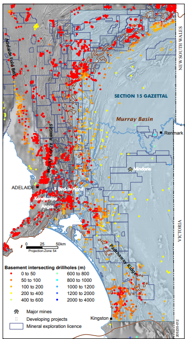
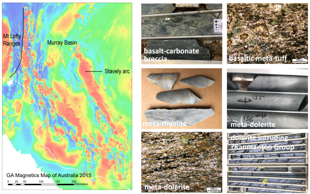
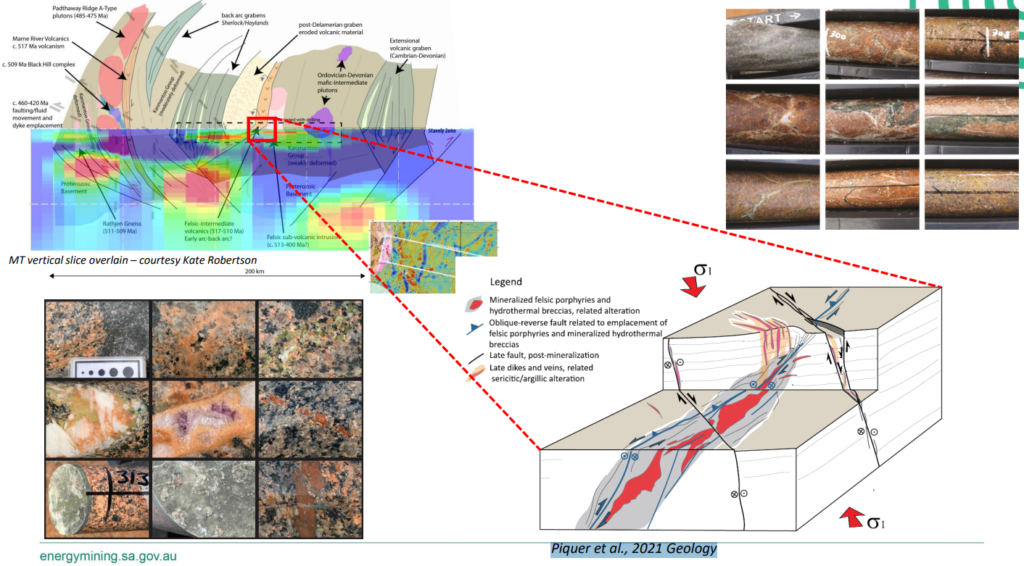
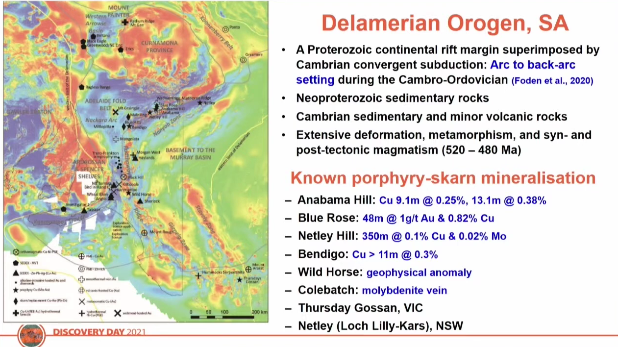
Use partner data to begin a Deposit Characterization study from regional to district scale in the Delamerian Region. We will apply AI/ML algorithms (such as unsupervised clustering) to examine how each deposit correlates with its geological setting and produce target maps / prospectivity zones. This enhanced study is contingent on access to rich datasets, concluding with a presentation of results with maps, confidence overlays, and commentary to the partner.
Month 4 Feedback iteration & refinement Work with partner geoscientists to review outputs; incorporate their feedback (structural corrections, known pins) and refine cleaning/curation + model fine-tuning.
Month 5-6 Prioritize drillable targets & due diligence From refined prospectivity maps, select 1–3 high-priority targets. Conduct desktop due diligence (review access, terrain, logistics, permitting). Begin environmental and heritage baseline studies (flora, fauna, hydrology).
Month 7–8 Small surface validation (if permitted) Conduct low-impact geochemical sampling, ground geophysics (magnetics, IP, resistivity) over target areas to validate anomalies.
Month 9 First scout drill design & budgeting Design a small scout drill program (1–2 holes) over the top target(s). Finalize budget, logistics, contractor selection.
Month 10–11 Drill contractor engagement & mobilization Secure drilling contractor, site access, supplies, site preparation. Mobilize to site.
Month 12 Begin drilling & first assays Drill first holes, retrieve core, submit samples, generate core logs + spectral scans. Begin combining real assay + core data back into your model pipeline for feedback + refinement.

Summary

In exploration, the real bottleneck isn’t running models, it’s getting the data to a usable, harmonised state. In many companies, geologists and data teams spend 50-70 % of their time on cleaning, aligning, gap-filling, reformatting, unit conversions, resolving depth mismatches, and reconciling conflicting datasets. The actual modeling (fault prediction, alteration mapping, prospectivity ranking) often becomes the “easy” step once the input is tidy.

Our software is built to change that. We automate the bulk of the data-curation pipeline: ingesting raw datasets (core photos, spectral logs, geochemistry, historical maps, structural logs), identifying gaps, misalignments, inconsistencies, and then proposing and executing transformations to deliver a single harmonised “model-ready” dataset. In practice with early trials, this means reducing weeks or months of manual prep to hours or days. 

Beyond cost savings, using our software leads to clearer, auditable data workflows (less human error), faster iteration (you can test alternate structural hypotheses or models more rapidly), and more reliable returns on modeling investment (you’re not chasing “garbage in → garbage out” problems). We don’t just create clearer mineral pictures, we free up geologists for more important work.

What We Do

Rapid adaptation to new deposits

Sparse and inconsistent data fusion

Model calibration and transfer between devices

Lightweight explainable on-prem inference

Transfer learning and continual improvement

About Us

Pioneering the Future Since 2019​